The success of any construction project hinges on a solid foundation, both literally and figuratively. Before laying the first brick, a thorough understanding of the land is essential. This is where topography and grading analysis come into play. These detailed processes shed light on the terrain's characteristics, laying the groundwork for informed decision-making and safe, sustainable construction.
Why Evaluating Terrain Matters
Taking the time to assess the land goes beyond mere procedure; it's an investment in the project's future. By carefully evaluating the terrain, architects can anticipate and address potential problems like flooding and erosion. This analysis ensures the constructed buildings seamlessly integrate with the natural landscape, enhancing both functionality and aesthetics.
Understanding Topography
Topography refers to the physical makeup of a land area, encompassing both natural and human-made features. It delves into the contours, elevations, and slopes that define the landscape. An accurate topographic analysis is the key element of effective site development. By understanding these topographical nuances, architects can design structures that fit harmoniously into the surroundings. Furthermore, topography plays a vital role in determining drainage patterns, potential vegetation impact, and the foundation requirements for the planned structures.
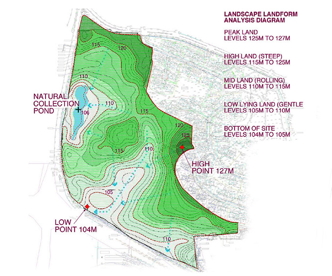
Topographic analysis_©worldlandscapearchitect.com
The Role of Grading Analysis in Construction
Grading analysis focuses on attentively assessing the land's slope and elevation to establish a level base for construction. This meticulous process is vital for ensuring the stability and structural integrity of the building foundation. By analyzing the grading, architects design effective drainage systems, preventing issues like water accumulation and soil erosion. Grading analysis is a critical step in preparing the site for construction and directly influences the project's overall success.
Key Elements of a Comprehensive Site Analysis Checklist
To ensure no stone is left unturned, a comprehensive site analysis checklist should encompass several crucial factors. This includes evaluating the soil type, the topography of the land, existing vegetation, water drainage patterns, and potential environmental hazards. Following a comprehensive checklist ensures all critical considerations are addressed before construction commences. A thorough site analysis empowers informed decisions, paving the way for project success and sustainability.
Here are some of the key elements that should be included in a site analysis checklist:
Soil composition: Different soil types have varying weight-bearing capacities, influencing the foundation design.
Topography: Understanding the slope, elevation, and natural features of the land is crucial.
Vegetation: The presence, type, and root systems of vegetation can impact construction planning.
Drainage patterns: Ensuring proper water flow away from the building foundation is essential.
Environmental hazards: Identifying potential environmental risks like wetlands or endangered species is necessary.
Initial Steps in Site Analysis: Setting the Stage
The first step in site analysis is conducting a thorough survey of the land. This survey involves collecting data on the topography, the soil composition, and the existing vegetation. Accurate data collection is fundamental for creating a reliable site plan. Surveying helps in understanding the specific characteristics of the terrain and pinpointing any potential obstacles. This initial step sets the stage for in-depth analysis and informed decision-making throughout the construction process.
The following are some tasks involved in the initial steps of site analysis:
Conducting a land survey to gather data on topography, soil, and vegetation.
Analyzing aerial photographs and satellite imagery for a broader perspective.
Consulting with local authorities regarding zoning regulations and environmental restrictions.
Assessing Natural Landforms
Natural landforms, such as hills, valleys, and plateaus, significantly impact where and how buildings are placed. Understanding these features allows for the design of structures that complement the natural environment, rather than disrupt it. Assessing landforms involves studying their shapes, sizes, and distribution across the landscape. This analysis plays a vital role in selecting suitable locations for buildings, ensuring stability and minimizing environmental impact.
Analyzing Soil Composition
Analyzing the soil composition is essential for determining the land's suitability for construction. Different soil types have varying load-bearing capacities, which directly influences the type of foundation required for the building. Soil analysis involves studying the soil's texture, structure, and moisture content. By understanding these soil properties, architects and engineers design foundations that ensure structural stability and prevent issues like settling or shifting of the building.
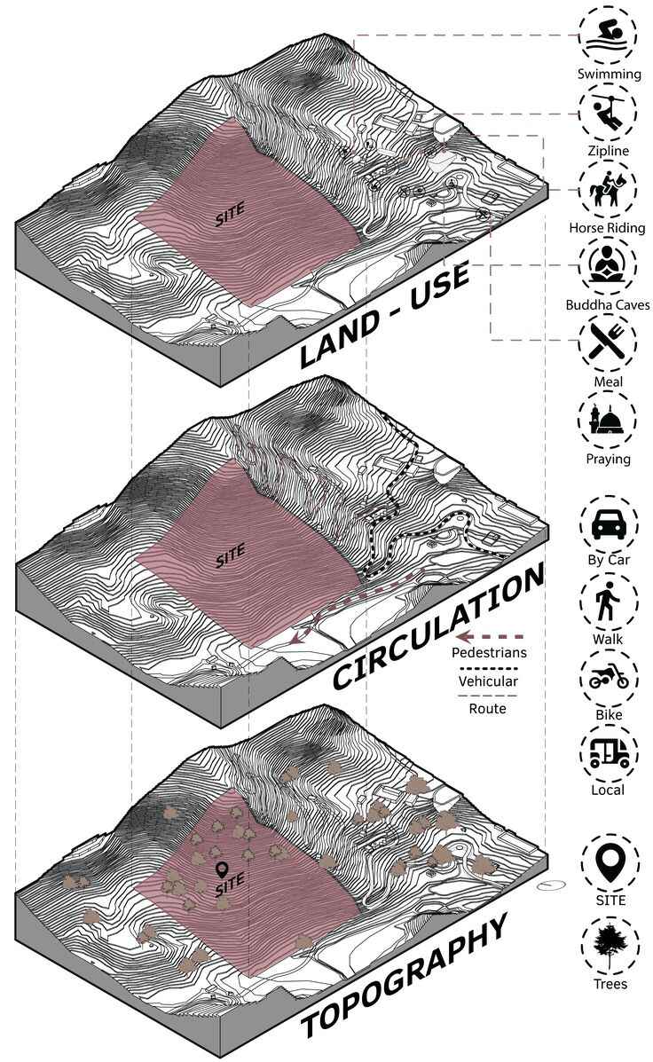
Site Analysis - Existing features_©Asra Bukhari on Pinterest.com
Identifying Potential Building Foundations
Choosing the most suitable foundation type is crucial for the long-term stability of the structure. Several factors play a role in this decision-making process, including the soil type, the topography of the land, and the water table levels. Identifying potential building foundations involves analyzing the land's characteristics and determining the most suitable foundation type to ensure the building's longevity and minimize risks associated with ground movement or instability.
Evaluating Drainage Patterns
Proper drainage is essential for preventing water accumulation around the building foundation. Analyzing natural drainage patterns on the land helps in designing effective water management systems. This evaluation involves studying the land's slope, the soil's permeability, and any existing drainage features. By understanding drainage patterns, architects can implement solutions to direct water away from the structure, preventing damage and erosion.
Considering Erosion and Sedimentation
Erosion and sedimentation can weaken the soil structure and pose risks to the building's foundation. Identifying areas prone to these issues allows for the implementation of preventive measures. This involves studying the land's topography, soil type, and vegetation cover. By understanding erosion and sedimentation patterns, architects can design strategies to stabilize the soil, such as planting vegetation or constructing retaining walls.
Impact of Vegetation on Building Placement
Vegetation can have both positive and negative impacts on building placement. While trees provide shade and reduce erosion, their root systems can also interfere with the foundation. A balanced approach is necessary. Assessing the vegetation involves studying the types of plants present, their distribution across the land, and their root systems. By understanding vegetation impact, architects design structures that harmonize with the natural environment and mitigate potential issues.
Using Technology for Accurate Terrain Mapping
Modern technology like Geographic Information Systems (GIS) and drones play a vital role in precise terrain mapping. These tools provide detailed topographic data, facilitating superior site analysis and planning. GIS integrates various data sources to create comprehensive maps, while drones capture high-resolution images and 3D models of the land. Utilizing these technologies enhances the accuracy and efficiency of terrain mapping, leading to more informed decision-making throughout the construction process.
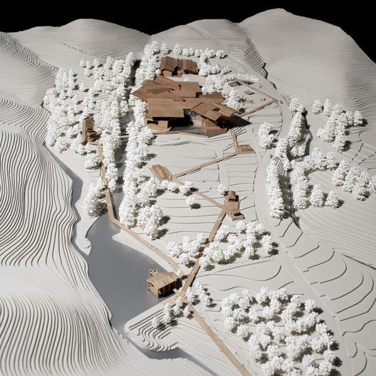
Physical model of New Pottery Museum in South Korea showcasing the site’s topography. Built by PWFERRETTO + UTOP in Goheung-gun, Korea, Republic of Seoul_©archdaily.com
How to Read and Interpret Topographic Maps
Topographic maps are essential tools in site analysis. They depict the contours, elevations, and slopes of the land, enabling planners to understand the terrain better and make informed decisions. Reading and interpreting topographic maps involve understanding contour lines, scale, and symbols. By mastering these skills, architects can accurately assess the land's characteristics and plan construction activities accordingly.
Creating a Grading Plan
A grading plan outlines the proposed changes to the land's elevation to create a suitable building site. This plan is critical for managing water flow and ensuring the structure's stability. Creating a grading plan involves analyzing the existing topography, designing the desired land contours, and planning the necessary earthwork. This rigorous process ensures proper drainage, prevents erosion, and provides a stable foundation for construction.
Environmental and Legal Considerations
Environmental and legal considerations must be factored into site analysis. This includes adhering to local zoning laws, environmental regulations, and obtaining necessary permits. Evaluating these factors involves understanding the land's ecological significance, potential environmental impacts of construction, and legal requirements. By considering environmental and legal aspects, architects can ensure compliance and minimize negative impacts on the environment, promoting sustainable construction practices.
Integrating Topography with Architectural Design
Integrating topography with architectural design ensures that the building harmonizes with the natural landscape. This approach enhances aesthetic appeal and minimizes environmental impact. By considering the land's contours, elevations, and natural features, architects design structures that blend seamlessly with the surroundings. This integration promotes sustainability and creates visually appealing and functional buildings.
Conclusion
In conclusion, a thorough understanding of topography and grading analysis is fundamental for successful construction projects. By meticulously evaluating the land, architects can make informed decisions that ensure stability, functionality, and sustainability. This comprehensive approach paves the way for the creation of structures that adhere to building code, are aesthetically pleasing, and respectful of the natural environment.
Master the process of site analysis! Our Guide to Site Analysis & Climate Study for Architects teaches you to assess terrain & design for a stable, sustainable building. Enroll today!
Visit the Kaarwan website for more insights!📈